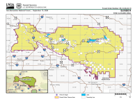
 The San Bernardino National Forest implemented the new Motor Vehicle Use Map this week, which, per Forest Supervisor Jeanne Wade Evans, puts them in compliance with the U.S. Forest Service Travel Management Rule. The new map is available to the public, free of charge, and identifies the system of designated roads and motorized trails available on the San Bernardino National Forest. The map identifies the roads and trails specifically designated for motor vehicle use, and also includes other public roads for navigational purposes; the new map does not display non-motorized recreational uses or facilities, so a Forest Visitor Map is still recommended for general information. Of the new maps, Forest Recreation Supervisor Fran Colwell says, “Public input and internal analyses helped point out specific locations for consideration while working through this process. Information the public shared with us helped update our road and trail data and our maps.” The new Motor Vehicle Use Map for the San Bernardino National Forest, which will be updated annually or as needed, will soon be available at the Big Bear Discovery Center and is currently available online, on the Off-Highway Vehicle page of the San Bernardino National Forest’s website.


