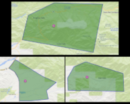
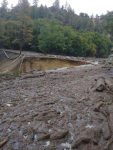
Big Bear News – San Bernardino, CA — The National Weather Service (NWS) is predicting heavy rainfall Tuesday morning and afternoon, with rain below the 5,000-foot level; meaning rain will melt the snowpack. Up to 6” of rain is possible in the valleys and mountains. Winds of up to 40 MPH are possible in the valleys and up to 70 MPH in the mountains and deserts. If the predicated rainfall amounts occur, there will be flooding, along with mud and debris flows and a strong possibility of mudslides in the recent burn areas.
Heavy rainfall can cause normally dry washes and riverbeds to become raging torrents in a very short amount of time and it only takes as little as 12 inches of moving water to move a vehicle. Never cross a road that you can’t see due to it being covered by water, remember, “Turn Around, Don’t Drown”.
While the county is preparing and residents have been given instructions on what they should do to get ready, people that live in areas that have burned recently are presented with unique challenges.
Normally, vegetation absorbs rain, but after a wildfire, the charred ground where that vegetation has been burned away creates a loss of soil strength and can no longer easily absorb rainwater, increasing the risk of flooding and mudflows for several years. Properties directly affected by fires, and those located downstream of burn areas, are most at risk.
Post-fire landslide hazards include fast-moving and highly destructive debris flows. Post-fire debris flows are particularly hazardous because they can occur with little warning, can exert great impulsive loads on objects in their paths, can strip vegetation, block drainage ways, damage structures, and endanger human life. Wildfires could potentially result in the destabilization of pre-existing deep-seated landslides over long time periods.
The best preparation for possible flooding is to plan. The Ready!Set!Go! Flood Preparation website (sbcfire.org/readysetgoflood) will show you some of the things you can do to protect your home, property and family. You’ll find information about how to prepare for wet weather, things like cleaning out rain gutters and storm drains, where you can sign up for emergency alerts, fire stations that have sandbags available, and what you should have in an emergency kit. There is also specific information for areas that have recently been burned by wildfire.
Sandbags can be extremely effective when used properly. Sandbags do not guarantee a water-tight seal, but properly placed sandbags can help redirect water, mud and debris away from your home. Find your closest sand and sandbag location at sbcfire.org/sandbags.
Weather Alert Terminology
When heavy rain has been forecast – or when heavy, steady rain is falling – monitor the news, websites and social media sites for updated weather conditions. The phrasing meteorologists use is important:
- Flood Watch means flooding is possible in your area.
- Flood Warning means flooding in your area is already occurring or is imminent.
- Flash Flood Warning is sudden violent flooding that is already occurring or is imminent. Flash floods often come up quickly during heavy rain and can be experienced in areas not immediately receiving rain.
Evacuation Terminology
Public Safety officials issue evacuations when there is an immediate/possible threat to the public. Never ignore an evacuation order/warning, as it could mean a matter of life or death.
- Evacuation Order: Immediate threat to life. This is a lawful order to leave now. The area is fully closed to public access.
- Evacuation Warning: Potential threat to life and/or property. Those who require additional time to evacuate, and those with pets and livestock should leave now.
- Shelter in Place: Go indoors. Shut and lock doors and windows. Prepare to self-sustain until further notice and/or contacted by emergency personnel for additional direction.


